


Geoglyphs and worldwide geometrical
symbols
Discovery of New Nazca!
Scientists
at
the
University
of
California,
Los
Angeles
discovered
new
Nazca
lines.
Although
not
exactly
in
Nazca,
but
in
the
Chincha
Valley,
located
in
the
vicinity
of
Nazca.
The
geoglyphs
are
associated
with
the
Paracas
culture,
which
was
located
around
350
kilometres
south
of
Lima,
and
is
300
years
older
than
the
Nasca
culture.
(About 400 - 100 BC).
In
the
“proceedings”
of
the
US
National
Academy
of
Sciences
[1],
Charles
Stanish,
the
head
of
the
academic
team,
reported
about
71
geoglyphs,
all
spanning
across
platforms
and
pyramidal,
running
along
lines
reported
to
be
several
kilometres
in
length.
Phenomenal!
And
because
the
new
lines
are
older
than
the
network
of
Nazca,
the
mystery
is
finally
solved.
The
Nazca
Indians
simply copied what had already been done by their predecessors of Paracas.
This
could
be.
There
are
several
scientific
datings
of
the
Nazca
geoglyphs,
which
point
to
the
lines
being
fairly
young
(between
200
and
600
AD)
[2].
But
none
have
found
which
line
is
the
oldest,
or
which
is
the
origin
of
all
the
lines
so
to
speak.
Who
began
the
lines
and
when?
And
why
did
the
later
generations
copy
the
exhausting
work
in
the
hot
desert?
Experts
note
that
many
of
the
new
lines
in
the
area
of
Palpa
aim
toward
a
point
where
the
sun
went
down
2300
years
ago
on
December
21.
It
was
“part
of
ritual
acts.
The
Paracas
cultures
created
an
artificial
landscape
in
the
desert
to
celebrate
recurring
social
events.”
[1].
Once
again,
it
comes
to
the
calendar.
To
operate
their
agriculture,
the
"social
societies"
needed
to
know
when
the
climate
changed.
As
if
they
could
not
read
out
on
a
wooden
stake,
a
rock
wall
marker,
or
simply
the
annually
recurring
changes
of
nature.
And
if
you
already
have
a
kilometre-long
line
on
the
angle
of
the
winter
sun
or
another
turn,
why
build
hundreds
more
of
them?
Also,
it's
not
only
about
lines
-
narrow
in
width,
with
similar
slopes
-
but
also
figures
that
can
only
be
seen
from
the
air:
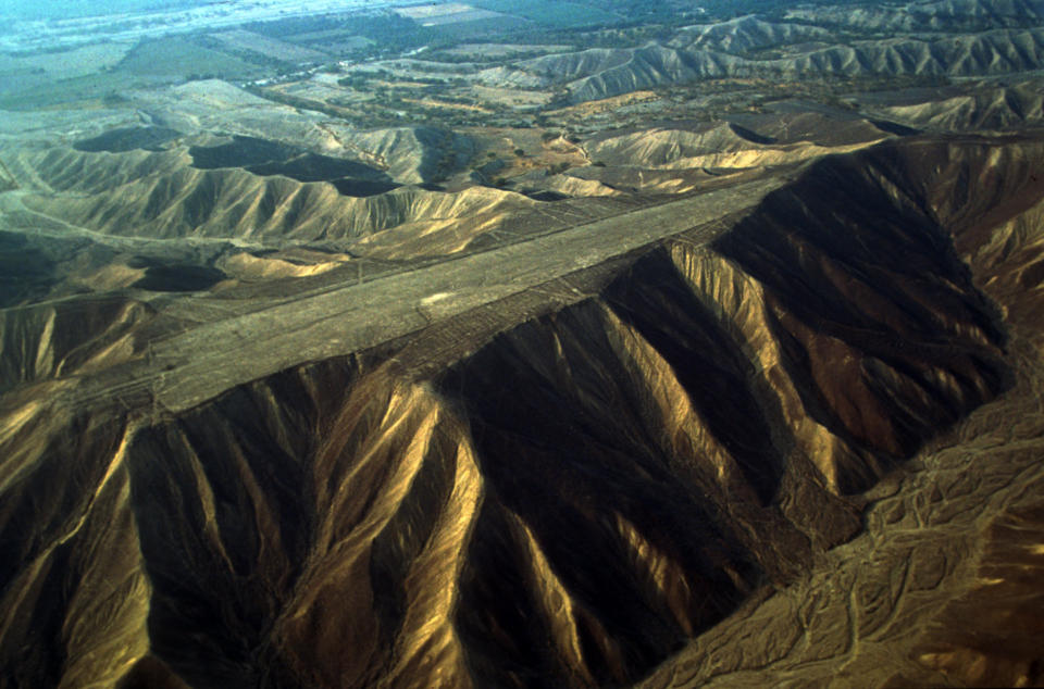
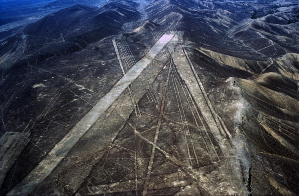
spider,
hummingbird,
monkey,
or
a
29
metre-high
figure
carved
into
a
hill.
The
latter
is
not
far
from
the
city
of
Ica,
in
the
Paracas
area,
where
the
natives
hammered
a
giant
helmeted
figure
into
a
rocky
plateau
so
that
it
is
visible
only
from
above.
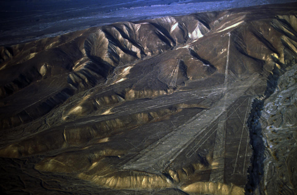
Lastly,
many
of
the
Nazca
Palpa
lines
are
not
on
a
calendrical point at all. So what were they doing?
The
calendar
option
and
the
“social
events”
may
be
honourable
proposals,
but
they
are
not
scientifically
as
important
as
other
lines
and
skyward-oriented
figures
that
are
not
included
in
the
model.
The
most
important
part
of
Nazca
Palpa
is
excluded.
Sure,
there
are
some
lines
on
calendrical
points.
I
do
not
dispute
that.
But
what
about
the
skyward-
oriented
geoglyphs
in
Jordan,
Saudi
Arabia,
the
Aral
Sea,
or
South
Africa?
What
about
the
hundreds
of
figures
from
the
Colorado
River
(United
States)
to
Mexico?
From
the
Rockies
to
the
Appalachians
on
the
north
side
of
America?
Worldwide,
this
involves
tens
of
thousands
of
lines,
characters,
figures,
and
wheels
(Images
1-7)
[3]
Many
cultures,
which
were
not
related,
who
knew
nothing
of
each
other,
created
huge
figures
in
the
ground.
Did
they
all
have
the
same
needs,
the
same
whimsy?
When
will
we
finally
understand
the
global
nature
of
this
phenomenon?
Surely
it
cannot
be
true
that
the
thousands
of
carved
drawings
on
other
continents
be
compared
with
the
Nazca?
And
how
long
will
it
take
the
academic
world,
how
long
until
clever
scientists
finally
involve
the
ancient
texts?
Especially
those
texts,
which
came
from
many
ancient
cultures
and
report
prehistoric
aviation?
[4,
5].
The
images,
lines,
and
figures
on
the
ground
were
clearly
reflected
in
ancient
literature.
The
relationships
are
obvious
and
the
texts
compelling.
I
suppose
the
ideologies
of
our
Stone
Age
ancestors
were
similar
all
over
the
world.
These
were
always
signs for the gods to signal those who were moving in the sky.
Scientific
statements
should
be
compulsory
-
but
with
respect
to
the
Nazca
however,
they
are
not.
On
one
hand,
it
is
unscientific
to
make
the
proper
assessment
by
showing
some
lines
on
calendrical
points,
while
on
the
other
hand
excluding
the
questions
about
why
the
Palpa
Indians
levelled
an
entire
hilltop
and
then
carved
a
zigzag
line
on
the
flattened
surface.
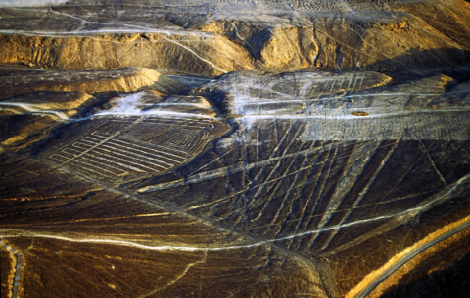
Additionally,
this
wide
Pista
zig-zag
line
has
no
calendrical
cardinal
point.
Years
ago,
geomagnetic
measurements
proved
strong
magnetic
changes
under
this
Pista
along
the
angled
lines.
A
quote
from
the
scientific
report
states:
“the
geomagnetic
measurements
revealed
clear
indications
of
subsurface
structures
that
differ
from
the
surface
geoglyphs.
The
high-resolution
geoelectric
images
show
unexpected
resistivity
anomalies
underneath
the
geoglyphs
down
to
a
depth
of
about
2
meters.” [6].
These
additional
scientific
findings,
published
in
Science
magazine,
find
no
resonance
of
“social
events.”
They
leave
us
with
calendar
and
“social
cults”
as
explanations,
while
revealing
something
mysterious
in
the
soil
along
several
lines.
We
are
left
to
wonder
what
methods
and
tools
the
indigenous
peoples
used
to
chip
away
at
the
mountaintop.
What
was
their
motive
for
the
hard
work,
and
where
is
the
excavation
material?
And
the
same
science
that
delivers
the
eternal
calendar
conclusion
cannot
tell
us
why
lines
were
created
that are entirely unrelated to the calendar.
In
Nazca
Palpa,
academic
archaeology
always
turned
a
blind
eye
when
it
came
to
the
gods.
Involving
gods
in
their
model
simply
does
not
fit
with
their
ideological
thinking.
Or
flying
crafts
that
once
actually
existed
and
have
nothing
to
do
with
their
religious-
psychological
dream
models.
We
are
not
spirits
that
merely
nod
and
assent
if
the
offered
answers are unsatisfactory. We keep researching and the drill continues.
[1] PNAS 1406501111/ 2014.
[2]
Lambers,
Karsten:
The
Geoglyphs
of
Palpa,
Peru.
German
Archaeological
Institute.
Aichwald 2006.
[3] von Däniken, Erich: Impossible truths. Rottenburg 2013.
[4]
Laufer,
Berthold:
The
Prehistory
of
Aviation.
Field
Museum
of
Natural
History,
Anthropological Series Vol XVIII, No. 1. Chicago 1928.
[5] Kanjilal, Dileep Kumar: Vimanas in Ancient India. Calcutta 1985.
[6]
Hartsch,
Kerstin,
et
al:
The
Nasca
and
Palpa
Geoglyphs:
Geophysical
and
Geochemical data. Science, July 2009.

Das Magazin SAGENHAFTE ZEITEN erscheint
6 Mal und kostet Euro 49 pro Jahr. Nur im Abo erhältlich:
www.sagenhaftezeiten.com


Geoglyphs and
worldwide geometrical
symbols
Discovery of New Nazca!
Scientists
at
the
University
of
California,
Los
Angeles
discovered
new
Nazca
lines.
Although
not
exactly
in
Nazca,
but
in
the
Chincha
Valley,
located
in
the
vicinity
of
Nazca.
The
geoglyphs
are
associated
with
the
Paracas
culture,
which
was
located
around
350
kilometres
south
of
Lima,
and
is
300
years
older
than
the
Nasca
culture.
(About
400 - 100 BC).
In
the
“proceedings”
of
the
US
National
Academy
of
Sciences
[1],
Charles
Stanish,
the
head
of
the
academic
team,
reported
about
71
geoglyphs,
all
spanning
across
platforms
and
pyramidal,
running
along
lines
reported
to
be
several
kilometres
in
length.
Phenomenal!
And
because
the
new
lines
are
older
than
the
network
of
Nazca,
the
mystery
is
finally
solved.
The
Nazca
Indians
simply
copied
what
had
already
been
done
by
their
predecessors
of Paracas.
This
could
be.
There
are
several
scientific
datings
of
the
Nazca
geoglyphs,
which
point
to
the
lines
being
fairly
young
(between
200
and
600
AD)
[2].
But
none
have
found
which
line
is
the
oldest,
or
which
is
the
origin
of
all
the
lines
so
to
speak.
Who
began
the
lines
and
when?
And
why
did
the
later
generations
copy
the
exhausting
work
in
the
hot
desert?
Experts
note
that
many
of
the
new
lines
in
the
area
of
Palpa
aim
toward
a
point
where
the
sun
went
down
2300
years
ago
on
December
21.
It
was
“part
of
ritual
acts.
The
Paracas
cultures
created
an
artificial
landscape
in
the
desert
to
celebrate recurring social events.” [1].
Once
again,
it
comes
to
the
calendar.
To
operate
their
agriculture,
the
"social
societies"
needed
to
know
when
the
climate
changed.
As
if
they
could
not
read
out
on
a
wooden
stake,
a
rock
wall
marker,
or
simply
the
annually
recurring
changes
of
nature.
And
if
you
already
have
a
kilometre-long
line
on
the
angle
of
the
winter
sun
or
another
turn,
why
build
hundreds
more
of
them?
Also,
it's
not
only
about
lines
-
narrow
in
width,
with
similar
slopes
-
but
also
figures
that
can
only
be
seen
from
the
air:
spider,
hummingbird,
monkey,
or
a
29
metre-high
figure
carved
into
a
hill.
The
latter
is
not
far
from
the
city
of
Ica,
in
the
Paracas
area,
where
the
natives
hammered
a
giant
helmeted
figure
into
a
rocky
plateau
so
that
it
is
visible
only
from
above.
Lastly,
many
of
the
Nazca
Palpa
lines
are
not
on
a
calendrical point at all. So what were they doing?
The
calendar
option
and
the
“social
events”
may
be
honourable
proposals,
but
they
are
not
scientifically
as
important
as
other
lines
and
skyward-oriented
figures
that
are
not
included
in
the
model.
The
most
important
part
of
Nazca
Palpa
is
excluded.
Sure,
there
are
some
lines
on
calendrical
points.
I
do
not
dispute
that.
But
what
about
the
skyward-oriented
geoglyphs
in
Jordan,
Saudi
Arabia,
the
Aral
Sea,
or
South
Africa?
What
about
the
hundreds
of
figures
from
the
Colorado
River
(United
States)
to
Mexico?
From
the
Rockies
to
the
Appalachians
on
the
north
side
of
America?
Worldwide,
this
involves
tens
of
thousands
of
lines,
characters,
figures,
and
wheels
(Images
1-7)
[3]
Many
cultures,
which
were
not
related,
who
knew
nothing
of
each
other,
created
huge
figures
in
the
ground.
Did
they
all
have
the
same
needs,
the
same
whimsy?
When
will
we
finally
understand
the
global
nature
of
this
phenomenon?
Surely
it
cannot
be
true
that
the
thousands
of
carved
drawings
on
other
continents
be
compared
with
the
Nazca?
And
how
long
will
it
take
the
academic
world,
how
long
until
clever
scientists
finally
involve
the
ancient
texts?
Especially
those
texts,
which
came
from
many
ancient
cultures
and
report
prehistoric
aviation?
[4,
5].
The
images,
lines,
and
figures
on
the
ground
were
clearly
reflected
in
ancient
literature.
The
relationships
are
obvious
and
the
texts
compelling.
I
suppose
the
ideologies
of
our
Stone
Age
ancestors
were
similar
all
over
the
world.
These
were
always
signs
for
the
gods
to
signal those who were moving in the sky.
Scientific
statements
should
be
compulsory
-
but
with
respect
to
the
Nazca
however,
they
are
not.
On
one
hand,
it
is
unscientific
to
make
the
proper
assessment
by
showing
some
lines
on
calendrical
points,
while
on
the
other
hand
excluding
the
questions
about
why
the
Palpa
Indians
levelled
an
entire
hilltop
and
then
carved
a
zigzag
line
on
the
flattened
surface.
Additionally,
this
wide
Pista
zig-
zag
line
has
no
calendrical
cardinal
point.
Years
ago,
geomagnetic
measurements
proved
strong
magnetic
changes
under
this
Pista
along
the
angled
lines.
A
quote
from
the
scientific
report
states:
“the
geomagnetic
measurements
revealed
clear
indications
of
subsurface
structures
that
differ
from
the
surface
geoglyphs.
The
high-resolution
geoelectric
images
show
unexpected
resistivity
anomalies
underneath
the
geoglyphs
down
to
a
depth of about 2 meters.” [6].
These
additional
scientific
findings,
published
in
Science
magazine,
find
no
resonance
of
“social
events.”
They
leave
us
with
calendar
and
“social
cults”
as
explanations,
while
revealing
something
mysterious
in
the
soil
along
several
lines.
We
are
left
to
wonder
what
methods
and
tools
the
indigenous
peoples
used
to
chip
away
at
the
mountaintop.
What
was
their
motive
for
the
hard
work,
and
where
is
the
excavation
material?
And
the
same
science
that
delivers
the
eternal
calendar
conclusion
cannot
tell
us
why
lines
were
created
that are entirely unrelated to the calendar.
In
Nazca
Palpa,
academic
archaeology
always
turned
a
blind
eye
when
it
came
to
the
gods.
Involving
gods
in
their
model
simply
does
not
fit
with
their
ideological
thinking.
Or
flying
crafts
that
once
actually
existed
and
have
nothing
to
do
with
their
religious-psychological
dream
models.
We
are
not
spirits
that
merely
nod
and
assent
if
the
offered
answers
are
unsatisfactory.
We
keep
researching and the drill continues.
[1] PNAS 1406501111/ 2014.
[2]
Lambers,
Karsten:
The
Geoglyphs
of
Palpa,
Peru.
German
Archaeological
Institute.
Aichwald
2006.
[3]
von
Däniken,
Erich:
Impossible
truths.
Rottenburg 2013.
[4]
Laufer,
Berthold:
The
Prehistory
of
Aviation.
Field
Museum
of
Natural
History,
Anthropological
Series Vol XVIII, No. 1. Chicago 1928.
[5]
Kanjilal,
Dileep
Kumar:
Vimanas
in
Ancient
India. Calcutta 1985.
[6]
Hartsch,
Kerstin,
et
al:
The
Nasca
and
Palpa
Geoglyphs:
Geophysical
and
Geochemical
data.
Science,
July
2009.


Das
Magazin
SAGENHAFTE
ZEITEN
erscheint
6
Mal
und
kostet
Euro
49
pro
Jahr.
Nur
im Abo erhältlich:
www.sagenhaftezeiten.com